- My Forums
- Tiger Rant
- LSU Recruiting
- SEC Rant
- Saints Talk
- Pelicans Talk
- More Sports Board
- Fantasy Sports
- Golf Board
- Soccer Board
- O-T Lounge
- Tech Board
- Home/Garden Board
- Outdoor Board
- Health/Fitness Board
- Movie/TV Board
- Book Board
- Music Board
- Political Talk
- Money Talk
- Fark Board
- Gaming Board
- Travel Board
- Food/Drink Board
- Ticket Exchange
- TD Help Board
Customize My Forums- View All Forums
- Show Left Links
- Topic Sort Options
- Trending Topics
- Recent Topics
- Active Topics
Started By
Message
re: Deep South Severe Weather Thread (Enhanced)
Posted on 10/27/21 at 10:13 am to NorthEndZone

Posted on 10/27/21 at 10:13 am to NorthEndZone
quote:
Looks like it has weakened. NWS now says capable of producing a tornado.
Yeah, the velocity couplet is not as tight as it was, but it certainly looks capable of tightening back up quickly.
 3
3


Posted on 10/27/21 at 10:36 am to Roll Tide Ravens
The line is looking pretty thicc and it’s got a chainsaw penis with a tornado on the tip of it.

Posted on 10/27/21 at 10:36 am to Roll Tide Ravens
I dont know shite about the weather, but damm, that is a fine line of storm coming in hot on LA.
Posted on 10/27/21 at 10:37 am to Shuga4689
New tornado watch for NW Louisiana.

Posted on 10/27/21 at 10:39 am to Roll Tide Ravens
The storm that produced the tornado earlier looks to be ramping back up again rotation wise. It has crossed into LA now.
ETA: We have a debris signature now. Tornado back on the ground.
ETA: We have a debris signature now. Tornado back on the ground.
This post was edited on 10/27/21 at 10:41 am
Posted on 10/27/21 at 10:42 am to The Boat
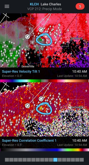
tBoat, I know about green and red on velocity, but what does the green and purple (on RadarScope non-pro) indicate? TIA
Posted on 10/27/21 at 10:43 am to SE TX TIGER
No video there
Posted on 10/27/21 at 10:44 am to Roll Tide Ravens
quote:
Meteorologist Nick Mikulas
I’m leaving now to head toward DeRidder. I won’t be posting warnings regularly since I will be on the road. I will live stream if I see anything interesting.
Nick Mik heading out to storm chase
Posted on 10/27/21 at 10:44 am to lachellie
The purple is just bad data
Posted on 10/27/21 at 10:46 am to Roll Tide Ravens
quote:Where baw?
The storm that produced the tornado earlier looks to be ramping back up again rotation wise. It has crossed into LA now. ETA: We have a debris signature now. Tornado back on the ground.
Posted on 10/27/21 at 10:47 am to Roll Tide Ravens
quote:
Meteorologist Nick Mikulas
Change of plans. Heading down 165 toward Oberlin instead. This is all fluid, and will change numerous times. I’ll steam at some point soon.
Posted on 10/27/21 at 10:53 am to White Bear
quote:
Where baw?
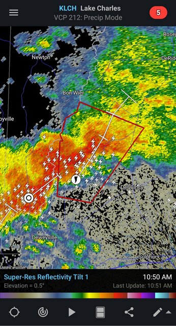
It would have been on the ground just inside the Southern end of the polygon.
Posted on 10/27/21 at 10:54 am to White Bear
quote:
Where baw?
On the tip of the line’s penis
Posted on 10/27/21 at 10:55 am to LegendInMyMind
Thx. Thought it was the NWLA nader.
Posted on 10/27/21 at 11:00 am to LegendInMyMind
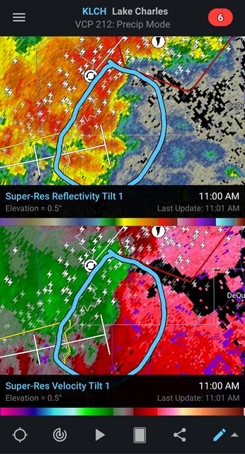
They trimmed the polygon back, but it won't take much for the notch in the line to the Southwest of it (nearly where the first tornado was) to get going. It looks suspicious.

Posted on 10/27/21 at 11:02 am to LegendInMyMind
Posted on 10/27/21 at 11:04 am to 50_Tiger
Anywhere in this area could be a problem.

Posted on 10/27/21 at 11:07 am to LegendInMyMind
SE Texas


This post was edited on 10/27/21 at 11:10 am

 Page 8 of 23

Popular
Back to top