- My Forums
- Tiger Rant
- LSU Recruiting
- SEC Rant
- Saints Talk
- Pelicans Talk
- More Sports Board
- Fantasy Sports
- Golf Board
- Soccer Board
- O-T Lounge
- Tech Board
- Home/Garden Board
- Outdoor Board
- Health/Fitness Board
- Movie/TV Board
- Book Board
- Music Board
- Political Talk
- Money Talk
- Fark Board
- Gaming Board
- Travel Board
- Food/Drink Board
- Ticket Exchange
- TD Help Board
Customize My Forums- View All Forums
- Show Left Links
- Topic Sort Options
- Trending Topics
- Recent Topics
- Active Topics
Started By
Message
5/6 Oklahoma/Kansas severe weather - High Risk- PDS Tor Watch
Posted on 5/5/24 at 10:09 am

Posted on 5/5/24 at 10:09 am
Loading Twitter/X Embed...
If tweet fails to load, click here. 


quote:
...Synopsis...
A potent shortwave trough is evident in water vapor imagery this
evening within the Great Basin. This feature will continue eastward
into the Four Corners by early this morning. An initial speed max is
expected to eject into western Kansas. By late afternoon into the
evening, another speed max will approach western Oklahoma. Deep
low-level moisture is already being observed in the BRO 00Z
sounding. Surface observations also show low 70s dewpoint as far
north as the DFW Metroplex this evening. As the trough approaches,
this moisture should stream northward. The overall synoptic setup
indicates a severe weather outbreak occurring this afternoon and
extending into the evening and parts of the overnight period.
Multiple intense, long-track tornadoes are expected, especially in
parts of southern Kansas into Oklahoma. Very-large hail of up 2-4
inches can also be expected with intense supercells. Severe gusts
may initially be isolated, but storm coverage should increase with
time as well as the mode becoming more linear. As this occurs,
severe gusts, some up to 80 mph, will become more common.
...Oklahoma into southern Kansas...
Intense storms are expected across these areas by late afternoon.
Storm coverage is likely to initially be greatest in south-central
Kansas given the greater and earlier upper-level forcing. Isolated
storms will still be possible along the dryline in western Oklahoma
as strong heating in the Texas Panhandle should support dryline
circulations that should at least locally erode inhibition. By the
evening, greater forcing for ascent will arrive in western Oklahoma.
Flow aloft will be nearly perpendicular to the dryline, which will
favor a discrete storm mode. Even as the weak Pacific front
overtakes the dryline, low-level forcing is not expected to be
strong enough to promote substantial upscale growth, especially when
coupled with continued strong shear across the boundary.
Overall, there appears to be prolonged opportunity for discrete
storms to form across western Oklahoma into parts of southern
Kansas. While the environment during the afternoon will certainly
support intense, long-track tornadoes, concern only grows by early
evening. Discrete storms are expected to move eastward into an
intensifying low-level jet core in central and eastern Oklahoma into
southeast Kansas. Surface-based activity will likely persist into
the evening and even parts of the overnight, given continued influx
of moisture and weak capping. The time frame of greatest concern for
intense tornadoes is from 03-06Z across central into northeast
Oklahoma.
This is a high-end environment. An upgrade to a tornado-driven High
Risk was considered. There remains some lingering uncertainty with
regard to the number of intense tornadoes that will occur. An
increase in tornado probabilities will certainly be warranted should
confidence in coverage and preferred corridors increase.
...Western Kansas into Nebraska...Iowa...Missouri...
Convection will likely initiate in western Kansas into southwest
Nebraska earlier than elsewhere given the timing of the upper-level
forcing. Furthermore, a linear mode should more quickly become
established due to the deep layer shear being oriented much more
parallel to the initiating boundary than farther south. Buoyancy
will generally decrease with northward extent. That being said,
moisture will continue to push northward through the day and into
the evening. Mid 60s F dewpoints could reach southeast Nebraska.
Strong deep-layer and low-level shear will promote an organized line
of convection capable of wind damage and QLCS tornadoes (some
potentially strong). There is some potential for discrete storms to
form ahead of the anticipated line. These storms would pose a
greater threat for significant tornadoes. Large to very large hail
will likely be more likely in western and central Kansas and
coverage of very large hail will be conditional on how long a
discrete mode is maintained.
...South Dakota...
Richer low-level moisture (upper 50s to perhaps near 60 F dewpoints)
will reach portions of central into northwest South Dakota. A narrow
zone of instability is expected to develop by the afternoon between
the cold and warm front. Large hail and severe gusts will be the
main threats, but low-level shear will be sufficient for a tornado
or two.
...Edwards Plateau into Texas Rolling Plains...
Storm coverage this far south should generally be much more isolated
on account of weak and nebulous forcing. However, a strong enough
dryline circulation could initiate convection within a strongly
unstable and sheared environment. Should storms form, large hail and
severe wind gusts would be possible.
..Wendt/Darrow.. 05/06/2024
In 3 hatched areas here in Wichita. My butt is pre puckered.
This post was edited on 5/6/24 at 4:15 pm
 19
19

Posted on 5/5/24 at 10:55 am to Pedro
Keep an eye out, Pedro, and find some cover for the vehicles.
Posted on 5/5/24 at 11:02 am to Pedro
MDT looks like a mitochondria, and the mitochondria is the powerhouse of the cell.
Posted on 5/5/24 at 11:10 am to Violent Hip Swivel
thank god it isn't Midechlorians - a force tornado would suck
Posted on 5/5/24 at 11:32 am to Thracken13
Can't wait to see the jammed rush hour traffic with storm chasers added in for OKC tomorrow. Hopefully people take it seriously, lot of local folks weren't super happy last weekend and felt it was overblown since it mostly ended up being a southern OK event.
Posted on 5/5/24 at 12:11 pm to LegendInMyMind
Funny enough I think I’ll be passing under the overpass (at least the location anyway the bridge has probably been replaced by now) where that couple filmed the ‘91 Andover tornado so I should be good.
Posted on 5/5/24 at 12:43 pm to Pedro
Moderate is a bad term they use. It sounds like average. Now if they said Mon was a 4 out of 5 scale that seems like a bigger deal.
Timing
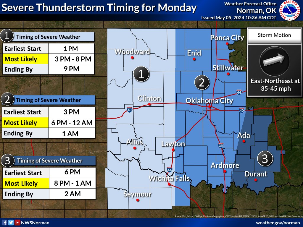
Timing
Posted on 5/5/24 at 12:50 pm to OU Guy
We talked about that a lot in atmos classes. Our professor brought up how they justify it in the nws office but for the public it’s not the best system, which is really what should matter.
Posted on 5/5/24 at 12:55 pm to Pedro
When they expanded the outlook types and added Enhanced they should have scrapped the whole thing in favor of something that made more sense to the general public. Their reasoning for not doing that is convoluted.
Posted on 5/5/24 at 1:00 pm to LegendInMyMind
Yea I get you can’t cater the whole system to the general public but things like this really should be
Posted on 5/5/24 at 1:11 pm to Pedro
Especially with how access has grown over recent years. It used to be that the only people who really saw the actual outlooks were newsrooms/on-air mets and the weather community. Now, anyone can get an app that puts the automatically updated 4 Day on your homescreen.
Posted on 5/5/24 at 5:55 pm to Pedro
A good little thread from NWS Norman:
First of all: tomorrow does not look like one of those days where every single person will see a storm.
Loading Twitter/X Embed...
If tweet fails to load, click here. quote:
We don't want you to get wrapped up too much in which color/category you're shown in in the outlook above. Yes, severe weather is *most* likely in the red and orange areas, but our entire area has a risk of severe weather that is high enough to need to pay attention to.
First of all: tomorrow does not look like one of those days where every single person will see a storm.
quote:
But if you are in an area that receives a storm, significant severe weather is possible, including strong tornadoes, very large hail, and destructive winds.
quote:
We know storm fatigue is real and that it's been a long couple of weeks. With that said, we want you to be ready for an impactful day of severe weather tomorrow. We'll be using this post to start a thread with some FAQs about tomorrow's risk, with updates throughout this evening.
Posted on 5/5/24 at 7:00 pm to LegendInMyMind
High would probably just be circled right over Wichita/andover at this rate
Posted on 5/5/24 at 7:01 pm to Pedro
Yeah, unfortunately.
Keep your head down tomorrow, bud. Are y'all having school?
Keep your head down tomorrow, bud. Are y'all having school?
Posted on 5/5/24 at 7:03 pm to LegendInMyMind
They don’t cancel for that here sadly. every school (in this area at least) has fema rated tornado shelters.
I’m switching districts this year and have a ton of sick days I need to use so I’m staying home and just going for practice after.
I’m switching districts this year and have a ton of sick days I need to use so I’m staying home and just going for practice after.

Posted on 5/5/24 at 7:08 pm to Pedro
The Significant Tornado Parameter for tomorrow evening from the HRRR has been nearly off the charts today.

Posted on 5/5/24 at 7:56 pm to Roll Tide Ravens

Posted on 5/5/24 at 9:29 pm to Pedro
could we see this upgraded to a high risk?
Posted on 5/5/24 at 10:34 pm to DVinBR
According to the Norman office, possibly, but also don’t worry because it doesn’t matter (also their words)
Posted on 5/5/24 at 10:36 pm to DVinBR
A word of advice to anyone thinking of doing storm chasing tomorrow. Road construction in south central and east central Kansas is brutal right now. It seems like they are either repaving every other road in the eastern half of the state or fixing a bridge on every other road in the eastern half of the state. Check Kandrive.org for closures and other obstacles due to road construction.

 Page 1 of 30

Popular
Back to top