- My Forums
- Tiger Rant
- LSU Recruiting
- SEC Rant
- Saints Talk
- Pelicans Talk
- More Sports Board
- Fantasy Sports
- Golf Board
- Soccer Board
- O-T Lounge
- Tech Board
- Home/Garden Board
- Outdoor Board
- Health/Fitness Board
- Movie/TV Board
- Book Board
- Music Board
- Political Talk
- Money Talk
- Fark Board
- Gaming Board
- Travel Board
- Food/Drink Board
- Ticket Exchange
- TD Help Board
Customize My Forums- View All Forums
- Show Left Links
- Topic Sort Options
- Trending Topics
- Recent Topics
- Active Topics
Started By
Message
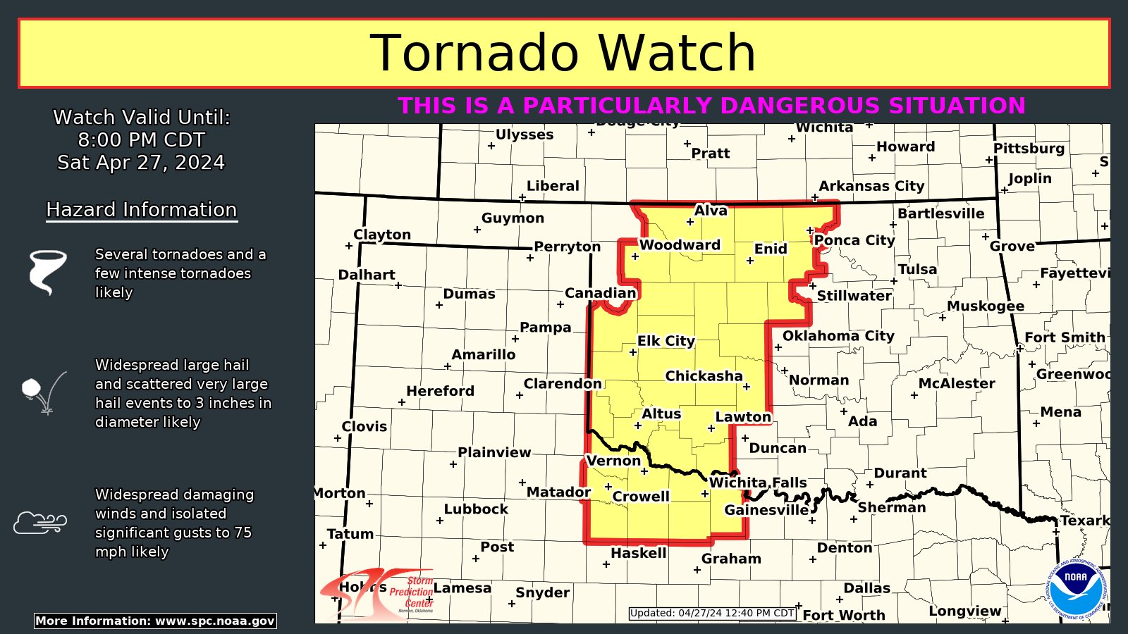
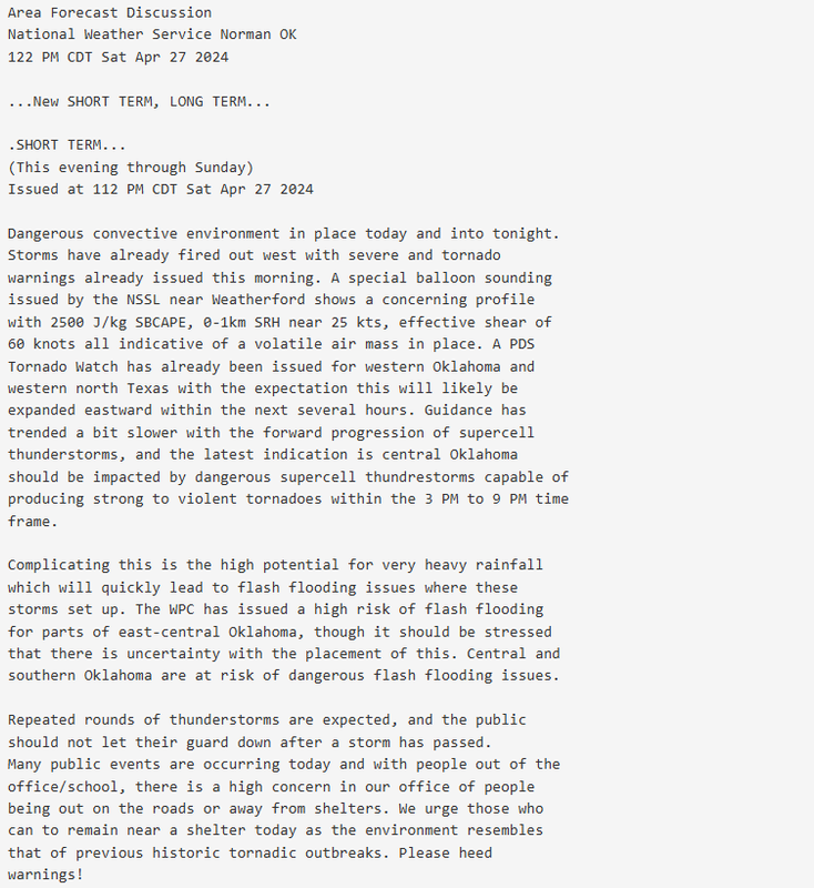
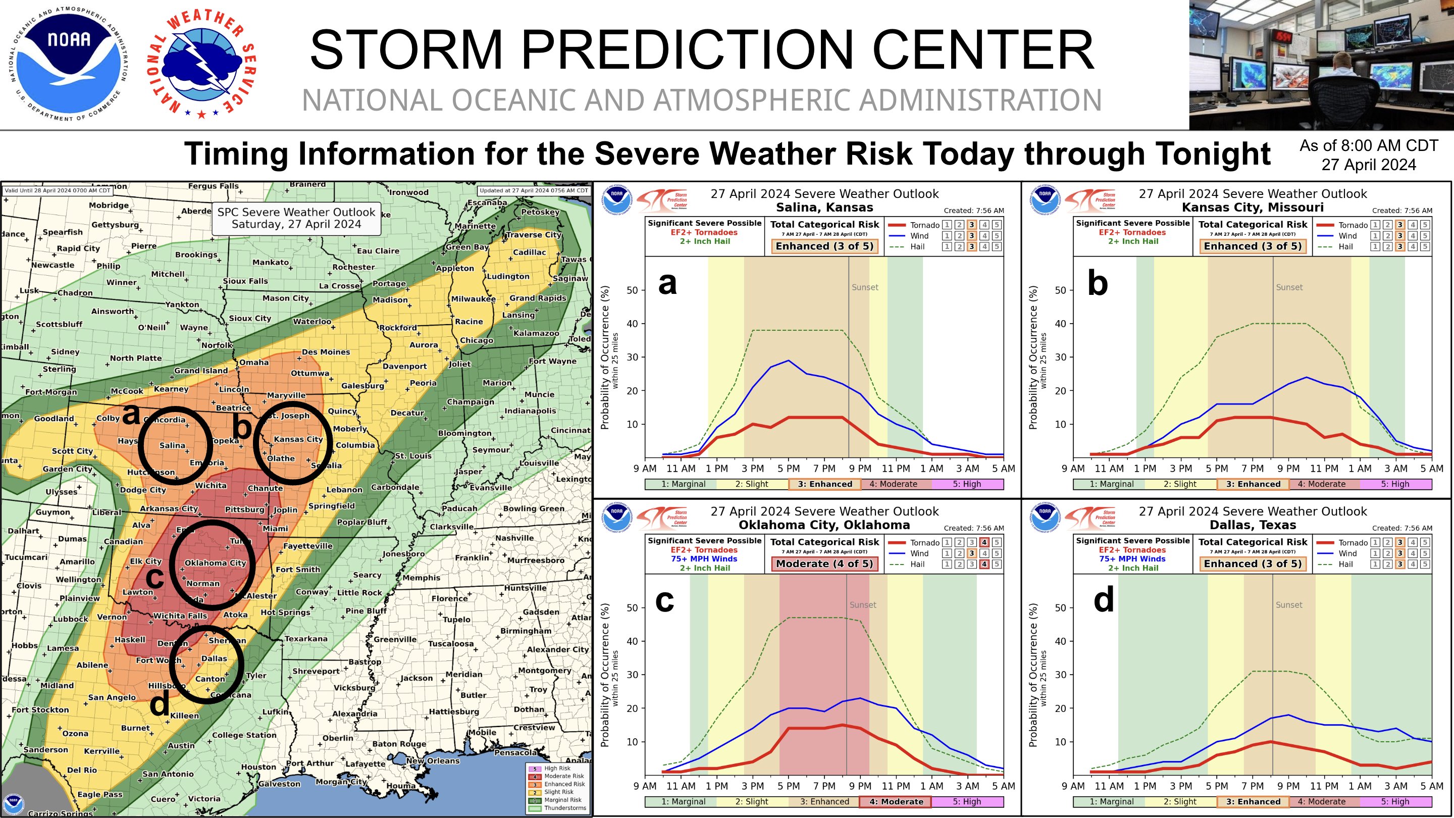
Central & Southern U.S. Severe Weather Continues: 4/27/2024 - 4/29/2024
Posted on 4/27/24 at 1:39 pm

Posted on 4/27/24 at 1:39 pm


This post was edited on 4/29/24 at 2:29 am
 13
13


Posted on 4/27/24 at 1:41 pm to Roll Tide Ravens

Posted on 4/27/24 at 1:45 pm to Roll Tide Ravens
Good OP. Great info.

Posted on 4/27/24 at 1:49 pm to Roll Tide Ravens
Moving over from other thread
Posted on 4/27/24 at 3:01 pm to Roll Tide Ravens
I have a lurker buddy who lives southeast of OKC, he's in for an interesting day(s)

Posted on 4/27/24 at 3:06 pm to Roll Tide Ravens
Looking at the precip radar forecast on the weather app, appears most of DFW wont't get the the "extreme" precip. Those northwest of the metroplex I hope yall stay safe
Posted on 4/27/24 at 7:50 pm to Roll Tide Ravens
Have had a most interesting day in North Texas. A lot of Weather Chasers; saw one tornado and numerous severe thunderstorms.
Traveled into the cells and along the squal line. Officiated a wedding in Seymour and traveled from and back to Wichita Falls... storms had an angry manner about themselves
Traveled into the cells and along the squal line. Officiated a wedding in Seymour and traveled from and back to Wichita Falls... storms had an angry manner about themselves
Posted on 4/27/24 at 8:18 pm to Roll Tide Ravens
Seems like we’ve avoided this event reaching its ceiling so far, which is great. I thought we would have another day much like yesterday. There have been a lot of tornado warnings, but not a lot of the big tornadoes like we saw yesterday.

Posted on 4/27/24 at 10:03 pm to Roll Tide Ravens
The current radar shows with its falls getting conveyor belted with purple radar.
Posted on 4/28/24 at 3:48 pm to Roll Tide Ravens
Loading Twitter/X Embed...
If tweet fails to load, click here.This post was edited on 4/28/24 at 3:49 pm
Posted on 4/28/24 at 6:53 pm to Roll Tide Ravens

Posted on 4/28/24 at 11:01 pm to Roll Tide Ravens
Pretty dangerous flash flooding situation going on basically along a line from College Station to Shreveport.
Posted on 4/29/24 at 8:11 pm to Roll Tide Ravens

 Page 1 of 1


Popular
Back to top