- My Forums
- Tiger Rant
- LSU Recruiting
- SEC Rant
- Saints Talk
- Pelicans Talk
- More Sports Board
- Fantasy Sports
- Golf Board
- Soccer Board
- O-T Lounge
- Tech Board
- Home/Garden Board
- Outdoor Board
- Health/Fitness Board
- Movie/TV Board
- Book Board
- Music Board
- Political Talk
- Money Talk
- Fark Board
- Gaming Board
- Travel Board
- Food/Drink Board
- Ticket Exchange
- TD Help Board
Customize My Forums- View All Forums
- Show Left Links
- Topic Sort Options
- Trending Topics
- Recent Topics
- Active Topics
Started By
Message
re: 5/6 Oklahoma/Kansas severe weather - High Risk- PDS Tor Watch
Posted on 5/6/24 at 2:15 pm to East Coast Band

Posted on 5/6/24 at 2:15 pm to East Coast Band
quote:
When is this literal shite storm commencing?
There are already some storms ongoing in Kansas, Nebraska and South Dakota, but I would say probably 4:00 or 5:00 PM CDT and onward for the high risk area.
This post was edited on 5/6/24 at 2:16 pm
 0
0


Posted on 5/6/24 at 2:16 pm to LegendInMyMind
Sun just came out here in the Tulsa metro. Currently 74 degrees, 82% humidity, and 68 dew point here in Jenks, OK.
Id prefer to not stay up until 2AM like I did a week or so ago. All you yahoos left me in the thread by myself.
Id prefer to not stay up until 2AM like I did a week or so ago. All you yahoos left me in the thread by myself.
Posted on 5/6/24 at 2:16 pm to East Coast Band
Things are forecasted to get going later this afternoon 5pm-midnight is the time frame for tornadic activity.

Posted on 5/6/24 at 2:17 pm to LegendInMyMind
I don’t mean apples to apples. I mean from a probability standpoint.
Posted on 5/6/24 at 2:21 pm to Hawgeye
First tornado of the day associated with the system. Butte County South Dakota
This post was edited on 5/6/24 at 2:28 pm
Posted on 5/6/24 at 2:22 pm to LSUGrrrl
quote:
I don’t mean apples to apples. I mean from a probability standpoint.
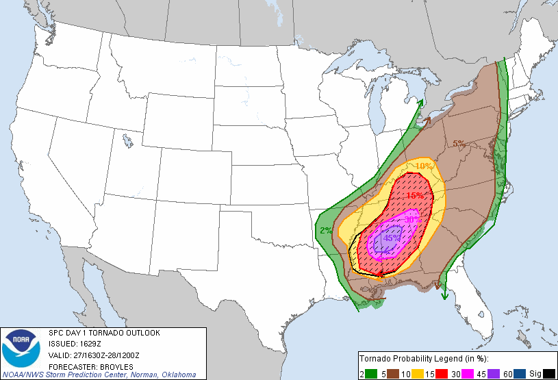
When it comes to tornadoes, April 27, 2011 had an ultra-rare 45% probability of tornadoes in the high risk area. Meaning there was a 45% chance of a tornado within 25 miles of any given point in that area.
*This graphic is from 4/27/11.*
This post was edited on 5/6/24 at 2:39 pm
Posted on 5/6/24 at 2:26 pm to LSUGrrrl
quote:
I don’t mean apples to apples. I mean from a probability standpoint.
They're both High Risk, so you have that. Duration of the most threatening supercell storms and how the setup should play out is entirely different. Shear was much higher on 4/27. There was enough CIN and the shear vector across a large geographical area was perfect so that it squashed any chance of those storms on 4/27 lining out. We don't have that with this setup. The window for discrete supercells is smaller than 4/27, these storms should line out tonight and could become a significant wind event as the line moves east into the night. The window where we will likely see discrete supercells fire has a very high ceiling.
Posted on 5/6/24 at 2:27 pm to Roll Tide Ravens
Wow. And today?
Also, I’ve been on this board way too long bc I don’t think I’m supposed to see what I do see in that map.

Posted on 5/6/24 at 2:29 pm to LSUGrrrl
PDS tor watch issued for south Kansas into Oklahoma.
Posted on 5/6/24 at 2:30 pm to LSUGrrrl
quote:
Wow. And today? Also, I’ve been on this board way too long bc I don’t think I’m supposed to see what I do see in that map.
Today the high risk area has the tornado probability in the 30%-44% bracket.
Like Legend said above, the thing to remember about 4/27/11 is that it was essentially a perfect setup. All of the ingredients were there in ample supply and there weren’t really any questions going into the event about whether things would come together. Most severe weather events, even high risk events like today, aren’t that way.
Posted on 5/6/24 at 2:30 pm to LegendInMyMind
Thought the graphic a couple pages back said they wouldn’t line out at least in OK.
1045am - we just did a briefing for close to 400 of our emergency management and television
partners. We thought it would be good to share some of the key point we discussed with them. - DO NOT FOCUS ON THE RISK CATEGORIES! It does not matter what category, color or number area you are in today. EVERY storm will be equally capable of producing dangerous tornadoes
and destructive hail. - Many (most?) people will NOT see any storms at all! We are only expecting a small number of storms. We could have 2-3, we could have 10. The thing to remember is if you see a storm near
you, assume it's a dangerous storm. - We have not experienced a day like this in quite some time. We expect storms to become supercells quickly after they form, and they should remain supercells through the event. We do
not expect them to form into a squall line or cluster.
- The potential for tornadoes will INCREASE after dark, so do not let your guard down. Wind shear - which is already plenty for tornadoes this afternoon - will only become more favorable after
dark. This is important!
- Clouds will NOT prevent storms from forming today or lessen their severity.
- The cap (a layer of warm air above the surface) will NOT prevent storms from forming today. - The timing graphic has our best analysis of when we think severe storms are most likely in your area. Please use this as a tool to help you make decisions about closings, cancellations, etc. Call us if you need more specific guidance. REMEMBER - many locations won't see a storm, but if you do,
it will be bad. IMPORTANT! please check the weather before you get in your vehicle this afternoon to leave work
or school. If there are storms nearby, consider delaying your trip!
Watch for further updates through the day.

Posted on 5/6/24 at 2:31 pm to Roll Tide Ravens
quote:
Probabilities within the new PDS tornado watch:
The last EF-5 was over 10 years ago. Did not realize that.
And there were 4 alone on one day in the 2011 outbreak.
Posted on 5/6/24 at 2:31 pm to Roll Tide Ravens
Got it. Thanks. Good perspective to have.
Posted on 5/6/24 at 2:32 pm to jcaz
quote:
The last EF-5 was over 10 years ago. Did not realize that. And there were 4 alone on one day in the 2011 outbreak.
Yep, the last one was in May 2013, hitting the OKC metro area (Moore, OK primarily).
Posted on 5/6/24 at 2:33 pm to LSUGrrrl
quote:
Thought the graphic a couple pages back said they wouldn’t line out at least in OK.
Hence, the window for discrete supercells to form.
What I said was strictly a comparison between how today could play out and how 4/27 did play out. With the afternoon storms on 4/27/11 you weren't getting a line of storms no matter how long you waited.
Posted on 5/6/24 at 2:33 pm to LSUGrrrl
I opened this thread up to your comment, clicked who you replied to (RTR), and saw the map before I read the text, and my heart dropped. I thought that was the probability map for this system.
Still unreal, that day. Never seen the atmosphere so unsettled. Every dark cloud seemed to be building into a monster.
I saw the Philadelphia, MS tornado damage up close (the one with some of the deepest ground scouring ever recorded, especially for a tornado moving 60mph), and it was, to say the least, unbelievable.
Posted on 5/6/24 at 2:34 pm to LegendInMyMind
I’m just glad this won’t be a night thing. My wife just asked if we should move the baby stuff downstairs to sleep in the guest bedroom tonight. That would’ve been a chore. 
Posted on 5/6/24 at 2:35 pm to mudshuvl05
quote:
opened this thread up to your comment, clicked who you replied to (RTR), and saw the map before I read the text, and my heart dropped. I thought that was the probability map for this system
Sorry about that!
Posted on 5/6/24 at 2:39 pm to Pedro
Prayers for y’all a safe afternoon and night especially with a newborn
Posted on 5/6/24 at 2:40 pm to Pedro
I'm in week 5 of a 14-16 week house remodel, so we are staying in the 5th wheel. We have it parked underneath one of my sheds off of one of my shop buildings.
It's hard as frick to sleep in a 5th wheel when it's pouring in these storms.
I wish it would stop raining and storms. My home lake has damn near shut down every boat ramp.
It's hard as frick to sleep in a 5th wheel when it's pouring in these storms.
I wish it would stop raining and storms. My home lake has damn near shut down every boat ramp.

 Page 6 of 30

Popular
Back to top