- My Forums
- Tiger Rant
- LSU Recruiting
- SEC Rant
- Saints Talk
- Pelicans Talk
- More Sports Board
- Fantasy Sports
- Golf Board
- Soccer Board
- O-T Lounge
- Tech Board
- Home/Garden Board
- Outdoor Board
- Health/Fitness Board
- Movie/TV Board
- Book Board
- Music Board
- Political Talk
- Money Talk
- Fark Board
- Gaming Board
- Travel Board
- Food/Drink Board
- Ticket Exchange
- TD Help Board
Customize My Forums- View All Forums
- Show Left Links
- Topic Sort Options
- Trending Topics
- Recent Topics
- Active Topics
Started By
Message
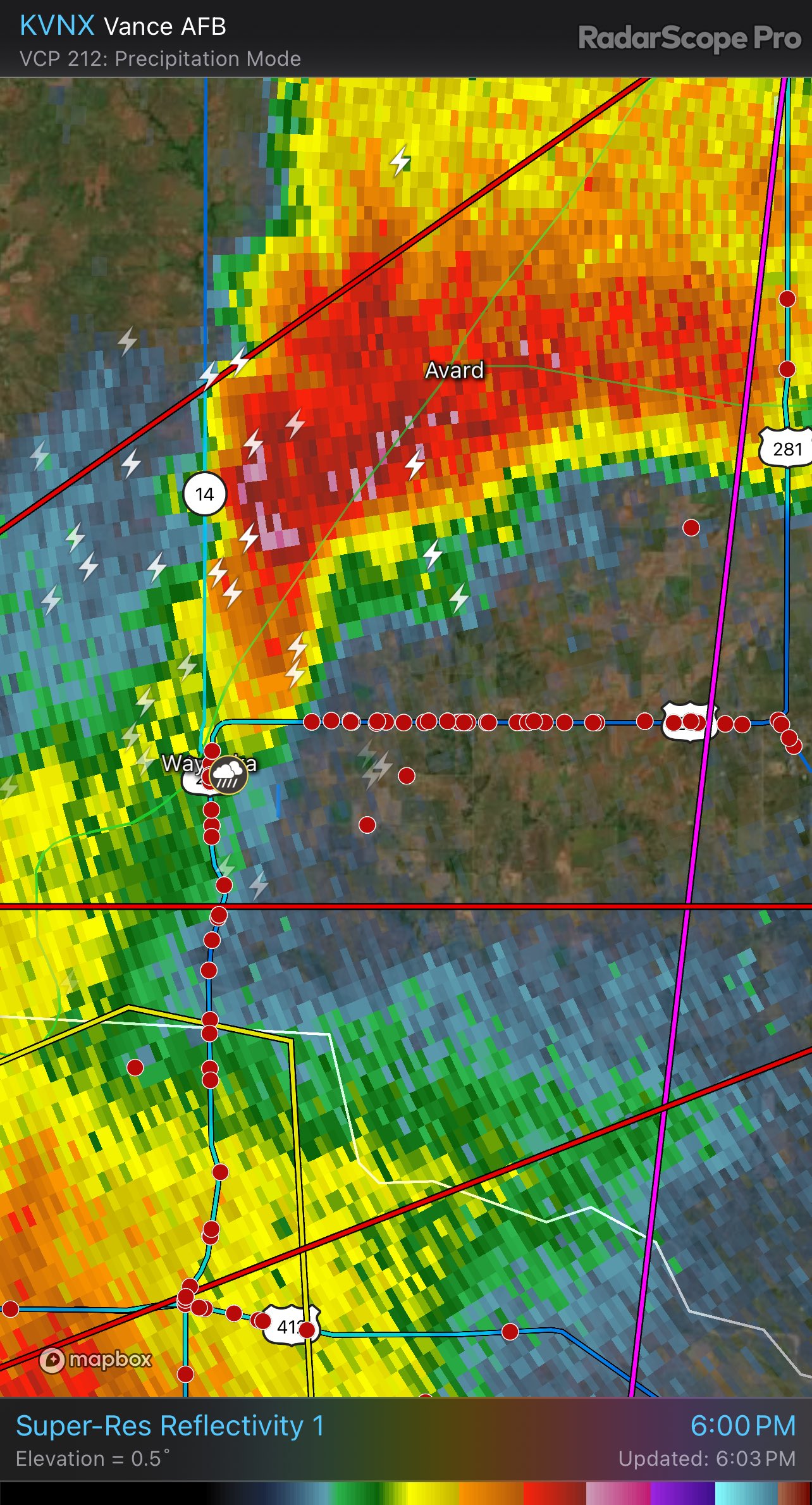
re: 5/6 Oklahoma/Kansas severe weather - High Risk- PDS Tor Watch
Posted on 5/6/24 at 5:13 pm to AHM21
Posted on 5/6/24 at 5:13 pm to AHM21
Look at all the chasers. And not all show up. They will cause a death at some point. And prevent TV chasers from getting the story, thus endangering many lives.
Payne is News9 OKC head weatherman
MdewakantonWinyan
@ExiledNoMo
·
3m
@tornadopayne saying while ago people from all over the world flew in for today & from the us & pay storm chasing companies to take them chasing . I’d forgotten about this issue ugh smh making it dangerous for all of us bc they wanna say they chased & get pcs video for$$
 3
3

Posted on 5/6/24 at 5:15 pm to OU Guy
As someone who experienced an EF-3 in a vehicle, I’ll gladly watch on a stream. It’s amazing sight to behold but you are correct - someone is going to die during one of these big events.
Posted on 5/6/24 at 5:18 pm to AHM21
Especially the potential for EF3+ to be rain wrapped and get caught up in it. One wrong turn and you’re dead
Posted on 5/6/24 at 5:26 pm to OU Guy
quote:
They will cause a death at some point. And prevent TV chasers from getting the story, thus endangering many lives.
If they die, they die.
This post was edited on 5/6/24 at 5:28 pm

Posted on 5/6/24 at 5:39 pm to DomincDecoco
Cell closing in on Hutchinson, Ks is trying to get its act together
Posted on 5/6/24 at 5:41 pm to DomincDecoco
NWS Norman
@NWSNorman
5:33pm - IMPORTANT - our message has not changed! We still expect the tornado potential to increase after 6:00 pm and persist well into the evening hours. The storms in NW OK are moving into a more favorable environment. We are not done. We're just getting started.
5:35 PM · May 6, 2024
Posted on 5/6/24 at 5:42 pm to DomincDecoco
[url=https://postimg.cc/SnJtBQWq]  [/url]
You beat me OU
[/url] You beat me OU
This post was edited on 5/6/24 at 5:43 pm
Posted on 5/6/24 at 5:44 pm to SWLA92
Reeds is trying it's damndest to drop one

Posted on 5/6/24 at 5:48 pm to Pedro
Checking in from the Alabama offices of the OT Storm Team.
Posted on 5/6/24 at 6:03 pm to OU Guy
quote:
Look at all the chasers. And not all show up. They will cause a death at some point. And prevent TV chasers from getting the story, thus endangering many lives.
Chaser convergence is an issue, but giving deference to "tv chasers" is a horshit reason to get your panties twisted over when media conglomerates rape storm chasers as practice. They're owned by billion dollar corporations that believe storm chasers make a living off of "credit". I'll never side with a news channel on this issue.
Posted on 5/6/24 at 6:04 pm to OU Guy
quote:
IMPORTANT - our message has not changed! We still expect the tornado potential to increase after 6:00 pm and persist well into the evening hours. The storms in NW OK are moving into a more favorable environment. We are not done. We're just getting started.
5:35 PM · May 6, 2024
Yep, just waiting on the LLJ to ramp up and the dry line to make it's way to the best area.
Posted on 5/6/24 at 6:05 pm to LegendInMyMind
quote:
Yep, just waiting on the LLJ to ramp up and the dry line to make it's way to the best area.
What height is best for viewing the LLJ on models? 850mb?
Posted on 5/6/24 at 6:05 pm to LegendInMyMind
I find it interesting the northern parts of central Oklahoma go to the Norman office and not Wichita.
I get it since it’s the same state and everything but it’s much close to the Wichita office
I get it since it’s the same state and everything but it’s much close to the Wichita office
This post was edited on 5/6/24 at 6:06 pm
Posted on 5/6/24 at 6:06 pm to DomincDecoco
quote:
If they die, they die.
They will. Lessons supposedly learned from El Reno have been forgotten. It won't necessarily be the people you believe it will be, though. El Reno took out even the most experienced.
Posted on 5/6/24 at 6:06 pm to Roll Tide Ravens
quote:
What height is best for viewing the LLJ on models? 850mb?
Yeah, 850.
Posted on 5/6/24 at 6:07 pm to LegendInMyMind
Whoever the serial downvoter is in here is committed to the grind. Respect, sir or maam.
This post was edited on 5/6/24 at 6:07 pm
Posted on 5/6/24 at 6:07 pm to LegendInMyMind
Someone is in here downvoting every post. 

Posted on 5/6/24 at 6:08 pm to Roll Tide Ravens
TigahRag’s ghost poster.
Posted on 5/6/24 at 6:08 pm to Pedro
quote:
I get it since it’s the same state and everything but it’s much close to the Wichita office
I imagine it is a lot like Cullman county Alabama, caught between two TV markets and everything gets complicated, even NWS office responsibility.
Posted on 5/6/24 at 6:08 pm to LegendInMyMind
quote:
Yeah, 850.


 Page 11 of 30

Popular
Back to top