- My Forums
- Tiger Rant
- LSU Recruiting
- SEC Rant
- Saints Talk
- Pelicans Talk
- More Sports Board
- Fantasy Sports
- Golf Board
- Soccer Board
- O-T Lounge
- Tech Board
- Home/Garden Board
- Outdoor Board
- Health/Fitness Board
- Movie/TV Board
- Book Board
- Music Board
- Political Talk
- Money Talk
- Fark Board
- Gaming Board
- Travel Board
- Food/Drink Board
- Ticket Exchange
- TD Help Board
Customize My Forums- View All Forums
- Show Left Links
- Topic Sort Options
- Trending Topics
- Recent Topics
- Active Topics
Started By
Message
re: Severe Weather Rolls On: May 7-10, 2024
Posted on 5/8/24 at 2:57 pm to LegendInMyMind
Posted on 5/8/24 at 2:57 pm to LegendInMyMind
The cells west of Charlotte look nasty.
This post was edited on 5/8/24 at 3:01 pm
 1
1

Posted on 5/8/24 at 2:58 pm to LegendInMyMind
quote:
The National Weather Service in Nashville has issued a
* Tornado Warning for... Eastern Montgomery County in Middle Tennessee... Northern Robertson County in Middle Tennessee...
* Until 315 PM CDT.
* At 247 PM CDT, a confirmed tornado was located 7 miles northwest of Coopertown, or 10 miles west of Springfield, moving northeast at 30 mph.
HAZARD...Damaging tornado and quarter size hail.
SOURCE...Weather spotters confirmed tornado.
IMPACT...Flying debris will be dangerous to those caught without shelter. Mobile homes will be damaged or destroyed. Damage to roofs, windows, and vehicles will occur. Tree damage is likely.
* The tornado will be near... Springfield around 255 PM CDT.
Other locations impacted by this tornadic thunderstorm include Cedar Hill, Adams, and Orlinda.
This includes Interstate 24 between mile markers 19 and 20.

Posted on 5/8/24 at 3:00 pm to jfan244888
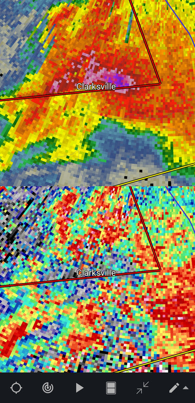
Storm east of Clarksville, TN. Confirmed tornado.

This post was edited on 5/8/24 at 3:01 pm

Posted on 5/8/24 at 3:00 pm to Roll Tide Ravens
We were going to try and prep some proteins for Here to Serve tomorrow. Doing 600# of chicken breasts and 48 butts. (To vacuum seal and freeze). We were planning for what may be an active hurricane season but now it looks like we might be needed in Tennessee or somewhere.
If anyone has significant damage over the next few days and we can help please let me know. We are capable of providing 600 lunches and 600 dinners for free.
I will be checking this post for replies if anyone needs help.
(And I am not wishing for damage or hurricanes but we try to prepare for the worst and hope for the best. Nothing will make me happier that donating our supplies to our local soup kitchens this fall).
Posted on 5/8/24 at 3:02 pm to Roll Tide Ravens
There's a huge rotation just south of Joplin Mo too.
Posted on 5/8/24 at 3:03 pm to Roll Tide Ravens
quote:
At 256 PM CDT, a confirmed tornado was located near Coopertown, or
near Springfield, moving northeast at 30 mph.
HAZARD...Damaging tornado and golf ball size hail.
SOURCE...Weather spotters confirmed tornado.
IMPACT...Flying debris will be dangerous to those caught without
shelter. Mobile homes will be damaged or destroyed. Damage
to roofs, windows, and vehicles will occur. Tree damage is
likely.
This tornado will be near...
Springfield around 300 PM CDT.
Cross Plains around 315 PM CDT.
Other locations impacted by this tornadic thunderstorm include Cedar
Hill, Adams, and Orlinda.
This includes Interstate 24 near mile marker 20.
Posted on 5/8/24 at 3:09 pm to Roll Tide Ravens
fricking a. I just took a break from sweating my arse off on my cab-less tractor all day and saw that I'm under that tornado watch.
Oh well. Time to get back on the beast at cut hay.
Oh well. Time to get back on the beast at cut hay.

Posted on 5/8/24 at 3:17 pm to El Segundo Guy
Tornado warning for Dover, TN. Gonna pass over Fort Donelson and LBL where I was Saturday
Posted on 5/8/24 at 3:20 pm to Pisco
I get the feeling this is going to be a long evening of severe weather.
Posted on 5/8/24 at 3:24 pm to NorthEndZone
PDS warning for Carterville,IL
BULLETIN - EAS ACTIVATION REQUESTED
Tornado Warning
National Weather Service Paducah KY
319 PM CDT Wed May 8 2024
The National Weather Service in Paducah has issued a
* Tornado Warning for...
Central Williamson County in southern Illinois...
* Until 400 PM CDT.
* At 319 PM CDT, a confirmed large and extremely dangerous tornado
was located near Carterville, moving east at 30 mph.
This is a PARTICULARLY DANGEROUS SITUATION. TAKE COVER NOW!
HAZARD...Damaging tornado.
SOURCE...Weather spotters confirmed tornado.
IMPACT...You are in a life-threatening situation. Flying debris
may be deadly to those caught without shelter. Mobile
homes will be destroyed. Considerable damage to homes,
businesses, and vehicles is likely and complete
destruction is possible.
* The tornado will be near...
Marion around 325 PM CDT.
Pittsburg around 335 PM CDT.
Other locations impacted by this tornadic thunderstorm include
Spillertown.
This includes Interstate 57 in Illinois between Mile Markers 48 and
56.
This post was edited on 5/8/24 at 3:26 pm
Posted on 5/8/24 at 3:29 pm to NorthEndZone
WPSD, WSIL and KFVS for the livestreams guys.
WSIL is based in Southern Illinois. All three are on the Carterville tornado
WSIL is based in Southern Illinois. All three are on the Carterville tornado
Posted on 5/8/24 at 3:30 pm to NorthEndZone
Those IL storms haven't had the best radar presentation, but they've put down a few tornadoes. They're lucky to have some spotters on them.
Posted on 5/8/24 at 3:36 pm to LegendInMyMind
WSIL took shelter for a while but are now out and broadcasting again.
This post was edited on 5/8/24 at 3:38 pm

Posted on 5/8/24 at 3:43 pm to NorthEndZone
Today seems like what Monday was supposed to be
Posted on 5/8/24 at 4:03 pm to Pedro
Some of these Tennessee storms are very concerning just based on radar presentation. We will see what they do.
Posted on 5/8/24 at 4:05 pm to Roll Tide Ravens
A warning already for a storm two counties north of here
Lovely
Just lovely
Lovely
Just lovely
Posted on 5/8/24 at 4:08 pm to Wishnitwas1998
Yeah, it is lighting up in TN right now. Every little storm or shower is rotating. How crowded it is does help, though.
Posted on 5/8/24 at 4:10 pm to LegendInMyMind
Warned for baseballs.

Posted on 5/8/24 at 4:11 pm to LegendInMyMind
Why am I under a Tornado Watch until 10:00 tonight? Thought we were sitting out this round.
Posted on 5/8/24 at 4:13 pm to LSUGrrrl
quote:
Why am I under a Tornado Watch until 10:00 tonight? Thought we were sitting out this round.
You sat out the past two days. You'll have a chance for storms with the front/dry line, hail being the biggest threat with any storm that can form.

 Page 8 of 36

Popular
Back to top