- My Forums
- Tiger Rant
- LSU Recruiting
- SEC Rant
- Saints Talk
- Pelicans Talk
- More Sports Board
- Fantasy Sports
- Golf Board
- Soccer Board
- O-T Lounge
- Tech Board
- Home/Garden Board
- Outdoor Board
- Health/Fitness Board
- Movie/TV Board
- Book Board
- Music Board
- Political Talk
- Money Talk
- Fark Board
- Gaming Board
- Travel Board
- Food/Drink Board
- Ticket Exchange
- TD Help Board
Customize My Forums- View All Forums
- Show Left Links
- Topic Sort Options
- Trending Topics
- Recent Topics
- Active Topics
Started By
Message
re: I-10 Severe Weather threat - Monday May 13, 2024...
Posted on 5/13/24 at 8:58 pm to Novastar

Posted on 5/13/24 at 8:58 pm to Novastar
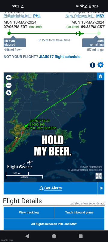
It's looking like the worst is about to pass over MSY now so there may be a chance of getting some planes in within the next 20-30 minutes. Tampa is going north now then will go west to avoid the line. Newark is probably headed out where San Diego has been circling. I would absolutely hate to be on the CRJ700 from Philly in this shite AA 5017
The spirit flight has finally diverted! To Pensacola NK 1526
United from Newark is diverting to Memphis United 1267
We have our first departure in roughly 45 minutes, DL 2094 to JFK DL 2094
The spirit flight has finally diverted! To Pensacola NK 1526
United from Newark is diverting to Memphis United 1267
We have our first departure in roughly 45 minutes, DL 2094 to JFK DL 2094
This post was edited on 5/13/24 at 9:05 pm
 4
4


Posted on 5/13/24 at 9:04 pm to CuseTiger
The severe thunderstorm warning for the Slidell area has an “Extremely Dangerous Situation” tag on it. Don’t see that every day.
Severe Thunderstorm Warning
National Weather Service New Orleans LA
852 PM CDT Mon May 13 2024
The National Weather Service in New Orleans has issued a
* Severe Thunderstorm Warning for... Northeastern Orleans Parish in southeastern Louisiana... Southeastern St. Tammany Parish in southeastern Louisiana... Hancock County in southern Mississippi...
* Until 945 PM CDT.
* At 851 PM CDT, severe thunderstorms were located along a line extending from Lacombe to East New Orleans, moving east at 40 mph.
HAZARD...70 mph wind gusts and quarter size hail.
SOURCE...Radar indicated.
IMPACT...Hail damage to vehicles is expected. Expect considerable tree damage. Wind damage is also likely to mobile homes, roofs, and outbuildings.
* Locations impacted include... New Orleans, Slidell, Bay St. Louis, Waveland, East New Orleans, Diamondhead, Pearl River, Lake Catherine, Kiln, Pearlington, Lacombe, Shoreline Park, Stennis Space Center, and Slidell Airport.
This includes the following Interstates... Interstate 10 in Louisiana between mile markers 246 and 256, and between mile markers 259 and 273. Interstate 10 in Mississippi between mile markers 1 and 16. Interstate 12 between mile markers 68 and 84. Interstate 59 in Louisiana between mile markers 1 and 11. Interstate 510 between mile markers 1 and 2.
PRECAUTIONARY/PREPAREDNESS ACTIONS...
This is an EXTREMELY DANGEROUS SITUATION. These storms are producing widespread wind damage. SEEK SHELTER NOW inside a sturdy structure and stay away from windows!

Posted on 5/13/24 at 9:05 pm to CuseTiger
Ok. My last one for the night...
Posted on 5/13/24 at 9:08 pm to CuseTiger
You can also see flights heading for western U.S. destinations from south Florida are turning northward toward Alabama to go around the storms.
Posted on 5/13/24 at 9:17 pm to CuseTiger
Looks like the Tampa to New Orleans Southwest flight is going to loop around and come in behind the storms.

 Page 1 of 1


Popular
Back to top