- My Forums
- Tiger Rant
- LSU Recruiting
- SEC Rant
- Saints Talk
- Pelicans Talk
- More Sports Board
- Fantasy Sports
- Golf Board
- Soccer Board
- O-T Lounge
- Tech Board
- Home/Garden Board
- Outdoor Board
- Health/Fitness Board
- Movie/TV Board
- Book Board
- Music Board
- Political Talk
- Money Talk
- Fark Board
- Gaming Board
- Travel Board
- Food/Drink Board
- Ticket Exchange
- TD Help Board
Customize My Forums- View All Forums
- Show Left Links
- Topic Sort Options
- Trending Topics
- Recent Topics
- Active Topics
Started By
Message

 0
0

Posted on 5/26/22 at 9:06 pm to TDsngumbo
Gustav was the worst hurricane I’ve experienced, and it wasn’t very nice. We left town for Ida. My neighborhood looked worse from Ida but I wasn’t there.
Neither of those storms hold a candle to what the 2016 tornado did. That shite frightens me still today.
Neither of those storms hold a candle to what the 2016 tornado did. That shite frightens me still today.
Posted on 5/26/22 at 9:11 pm to LegendInMyMind
quote:

My house was smack dab in that orange blob between Larose and Galliano.
I had double plane windows that were blown in on one side and a set of windows on the other side that were blow out.
I had an oak tree that cracked right on my roof. My neighbor had pine trees that were stripped of their bark.
Another neighbor had an exterior brick wall that was reduced to rubble.
Every Entergy pole in my street was either leaning or cracked in half.
2 large metal storage buildings had their exterior stripped and contents exposed. One of them was just finished days before the storm.
I also heard there were large swells in the bayou inside the levee system creating a mini surge and overtopped some areas.
So, I would say the winds were pretty strong. Whether it was 150 or 156, I think we are splitting hairs. Luckily, I was somewhere else when she blew ashore.
This post was edited on 5/26/22 at 9:20 pm
Posted on 5/26/22 at 9:12 pm to TDsngumbo
Just saying his opinion.
I think comparing destruction in Pville to the Gulf Coast is a bit extreme in any hurricane.
I think comparing destruction in Pville to the Gulf Coast is a bit extreme in any hurricane.
Posted on 5/26/22 at 9:26 pm to TDsngumbo
quote:
and I was in Donaldsonville for Gustav.
So you weren't even in your current location for Katrina nor Gustav and are speaking to the conditions?
Posted on 5/26/22 at 9:30 pm to LSUguy2023
quote:
was in the manchac lake apartments that Sunday night. It’s the big complex right by bayou manchac on airline highway by the parish line with EBR. We were on the 3rd floor and got 5 or 6 readings of gusts over 100mph. From what I remember, the sustained winds stayed in the 80s where we were.
Huh? Michael hit Panama city
He showed over 200
Posted on 5/26/22 at 9:46 pm to Tarps99
quote:
So, I would say the winds were pretty strong. Whether it was 150 or 156, I think we are splitting hairs. Luckily, I was somewhere else when she blew ashore.
My point of posting that radar grab was to highlight the structure and characteristics of the eye wall. The reason I said that sitting in that eye wall for hours would not give you the "normal" or usual hurricane damage is because Ida's eye wall was full of mesovortices. Prior to Ida beginning to make its turn after landfall it slowed down, nearly stalling. That slow down in forward motion, and interaction with land only served to increase those mesovortices.
In Houma, which saw nothing but the eye wall, never getting in the eye, the satellite pictures of the damage was more like that of a tornado in many places. You didn't only see the trees all laid down in one direction. You didn't see roofs off and the debris scattered all in the same direction. In some places you could see the "This house is gone, but that one took comparatively little damage" that you always see with tornadoes. There was some wind rowing of debris, too.
This is a gif of Ida from early in that timeframe:
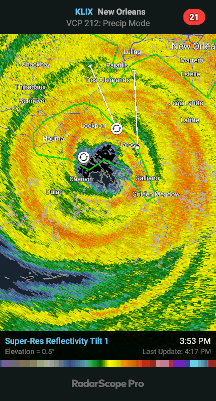
Every little hook within that inner eye wall is a potential tornado. Every one of those mesovortices could cause tornado-like damage. They would have had winds much higher than the overall or maximum recorded wind speeds of the hurricane.
That's why I say that if you spend a few hours in an eye wall that looks like that, the damage you get won't necessarily look like a typical hurricane.
Posted on 5/26/22 at 10:01 pm to LegendInMyMind
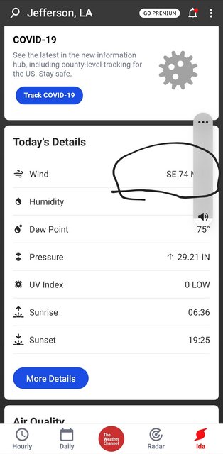
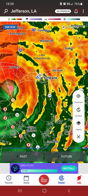
These are all from the same day timestamps in ss I thought it seemed pretty low
ETA correct link for 2 img, the post has no punch without it
This post was edited on 5/26/22 at 11:29 pm

Posted on 5/26/22 at 10:36 pm to LegendInMyMind
I've wondered about this post Ida, perceived winds and damage vs actual winds reported by NWS and others. We're halfway between Ponchy and Springfield and wind velocities seemed 20-30 mph above official post storm values closest to us.
Unfortunately, I don't have a home anemometer. I've worked offshore and years ago as a commercial pilot on smaller multi-engine aircraft used for scientific missions, and have a decent layman's ability to estimate wind velocity.
When the second pine tree trunk came through the master bathroom roof I was thinking this was going to be a stupid way to die. We hid in the master bedroom closet with no outside walls, and just last month finished all repairs.
Discussing with some Nola friends where I'm from, the idea we all had for years to evacuate to the safety of Baton Rouge is no longer operative.
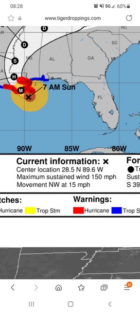
Two graphics of interest.


Unfortunately, I don't have a home anemometer. I've worked offshore and years ago as a commercial pilot on smaller multi-engine aircraft used for scientific missions, and have a decent layman's ability to estimate wind velocity.
When the second pine tree trunk came through the master bathroom roof I was thinking this was going to be a stupid way to die. We hid in the master bedroom closet with no outside walls, and just last month finished all repairs.
Discussing with some Nola friends where I'm from, the idea we all had for years to evacuate to the safety of Baton Rouge is no longer operative.
Two graphics of interest.

Posted on 5/26/22 at 10:46 pm to TheFonz
quote:
If anyone can tell me what the max sustained and max wind gusts were in Madisonville, I'd like to know.
Longest fricking night of my life.
I don't know but I can tell you this. I stayed with my cousin in Madisonville off of Helen Drive and it got real bad. I just thought the damage was bad there until 2 days later when we were finally able to make it my house close to Ponchatoula High. It was way worse in Ponchatoula. My cousin had power back by Saturday evening. It took 3 weeks before I got power back. Them stats above are in no way accurate. So I am supposed to believe that wind gust were only 59 mph in Hammond but were 111 mph in Mandeville 25 miles away? Am I also supposed to believe that Hammond in the eastern eye wall and closer to the eye had lower winds than BR further away and on the west side?
This post was edited on 5/26/22 at 10:54 pm

Posted on 5/26/22 at 11:05 pm to Ponchy Tiger
Insurance company always hire these assholes to try to say winds were not significant to cause the damages that were obviously caused by the storm so they have excuse to deny the claims.
It’s total bullshite
It’s total bullshite
Posted on 5/26/22 at 11:57 pm to Mr Breeze
I’ve lived off ONeal and I-12 in BR since 1991. Gustav and Ida have been the worst … maybe.
Andrew in 1992 toppled 41 (actual count) red oaks in our subdivision and left no subsequent tree comparisons to be made.
All were scary. Hope the Lord spares La. this year.
Andrew in 1992 toppled 41 (actual count) red oaks in our subdivision and left no subsequent tree comparisons to be made.
All were scary. Hope the Lord spares La. this year.
Posted on 5/27/22 at 2:01 am to Ponchy Tiger
Ain't no way that Hammond reading is correct. I was in the SLU parking garage that night watching it come in.
Posted on 5/27/22 at 2:13 am to burgeman
Needs a 1 in the front for sure.
Killian had the worst tree damage I have ever seen. I saw multiple uprooted cypress trees, which I didn’t know was possible.
Killian had the worst tree damage I have ever seen. I saw multiple uprooted cypress trees, which I didn’t know was possible.
Posted on 5/27/22 at 3:09 am to TDsngumbo
Bruh... Wind gusts at my house close to old Mandeville hit at least 120 mph. I've never seen 90 foot tall pines that are almost 4 feet in diameter snap like twigs, and I stayed during Katrina... Ida was a monster. I still have PTSD from that night.
Posted on 5/27/22 at 5:40 am to LegendInMyMind
quote:
Every little hook within that inner eye wall is a potential tornado. Every one of those mesovortices could cause tornado-like damage. They would have had winds much higher than the overall or maximum recorded wind speeds of the hurricane.
It may even go deeper than that. There could have had hundreds of microcells that far exceeded the resolution of the radar.
You can go to NOAA’s Ida imagery website to see the debris signatures, and to draw nearly straight lines to follow the damage and debris.
Speaking of the radar, with the distance between Terrebonne/Lafourche and Slidell, the radar has to go though so much of the storm that somethings get harder for the radar to see.
Also, in NOAA’s grand scheme to get Baton Rouge better coverage, they are planning on moving the Slidell Radar site to Hammond at the end of this year. They will be able to lower the beam to 0.3 degrees to see closer to the ground.

I would have moved the radar to LaPlace or Vacherie to help cover the bayou areas and to see deeper in the gulf.
One other thing to remember about storms is that the higher you are the stronger the winds. So the winds on the 6th floor are going to be different than on the ground. And also if multiple tall buildings are present, that can increase winds. That why NOAA discounted the readings in Fourchon. The wind gauge was about 50-100 feet up and near the tall Cport warehouses.
I had a neighbor who lives in a small brick house that is low to the ground. It has a low pitch roof that had almost no damage. The roof was fairly new, and I don’t think a shingle was out of place.
This post was edited on 5/27/22 at 7:34 am
Posted on 5/27/22 at 7:08 am to Tarps99
One of those spinups smoked part of my yard. 3 pines, 2 gums, 2 magnolias, 2 oaks...all in a row and snapped or twisted at their bases.

Posted on 5/28/22 at 7:49 am to the LSUSaint
I’ve been told by folks that should know that a storm being classified as Cat 5 drives up insurance costs, as well as raising the standards for rebuilding (costing homeowners and insurance companies more $). I seem to remember instances were they (somewhat quietly) came back years later and claimed to have new data and raised their ratings.

 Page 4 of 4


Popular
Back to top