- My Forums
- Tiger Rant
- LSU Recruiting
- SEC Rant
- Saints Talk
- Pelicans Talk
- More Sports Board
- Fantasy Sports
- Golf Board
- Soccer Board
- O-T Lounge
- Tech Board
- Home/Garden Board
- Outdoor Board
- Health/Fitness Board
- Movie/TV Board
- Book Board
- Music Board
- Political Talk
- Money Talk
- Fark Board
- Gaming Board
- Travel Board
- Food/Drink Board
- Ticket Exchange
- TD Help Board
Customize My Forums- View All Forums
- Show Left Links
- Topic Sort Options
- Trending Topics
- Recent Topics
- Active Topics
Started By
Message
re: Southeast Severe Weather: 12/28 - 12/29
Posted on 12/28/24 at 1:20 pm to biggsc
Posted on 12/28/24 at 1:20 pm to biggsc
Abc 13 reporting multiple homes destroyed between alvin and algoa major debris across 35 near hwy 6 and Dickinson now in peril.
Looks to be the same cell that passed lver my house 40 mins ago that spun up this alvin tornado.
Looks to be the same cell that passed lver my house 40 mins ago that spun up this alvin tornado.
This post was edited on 12/28/24 at 1:22 pm
 2
2

Posted on 12/28/24 at 1:21 pm to Tiger Ryno
The rotation has broadened now. The closer it gets to the radar the messier it is going to look, though.
Posted on 12/28/24 at 1:25 pm to LegendInMyMind
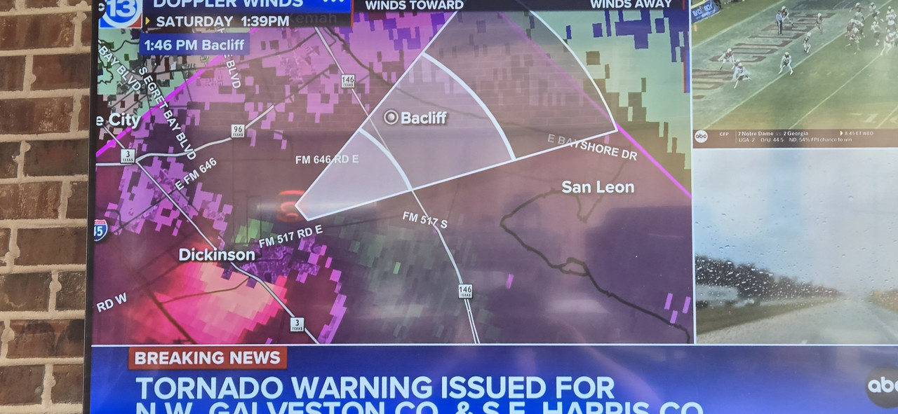
Just crossed Hwy 6 north and NW of Santa Fe. Moving NE at 20. Warning extended into Dickinson, south side of League City.
Still radar confirmed but getting close to Hobby radar so hard to detect details.
Cemetery Rd and FM 517 area next.
Still radar confirmed but getting close to Hobby radar so hard to detect details.
Cemetery Rd and FM 517 area next.
This post was edited on 12/28/24 at 1:27 pm
Posted on 12/28/24 at 1:26 pm to NorthEndZone
No other radars are close enough to help, either. Maybe some of the local stations have a radar with a better look.
Posted on 12/28/24 at 1:29 pm to LegendInMyMind
Extending the warning all the way to the bay.
Posted on 12/28/24 at 1:29 pm to Tiger Ryno
props to ABC13 and their radar monitoring. I was watching it all live and they were predicting a tornado to tough down ahead of time
Posted on 12/28/24 at 1:30 pm to NorthEndZone
You can really see the inflow on that storm now.
Posted on 12/28/24 at 1:30 pm to Klark Kent
Indeed. These guys are doing a great job today.
Posted on 12/28/24 at 1:36 pm to LegendInMyMind
Wow at this transtar camera shot on ABC13. That wind is ripping.
This post was edited on 12/28/24 at 1:38 pm
Posted on 12/28/24 at 1:37 pm to LegendInMyMind
Posted on 12/28/24 at 1:37 pm to LegendInMyMind
What about the polar vortex coming down by Jan 11th. Is it still too early to give temps during that time?
Posted on 12/28/24 at 1:38 pm to LegendInMyMind
These peoole driving on 45 right now near hughes rd have to have some mega puckered b holes right now.
Posted on 12/28/24 at 1:38 pm to G2160
Juuuust missing the radar now.
Posted on 12/28/24 at 1:38 pm to LegendInMyMind
is that a tornado just south of Dickinson?
Posted on 12/28/24 at 1:38 pm to LegendInMyMind
Between I-45 and TX Hwy 3 now. Just showed part of it on TX DOT camera moving across I-45.
ETA - now over Dickinson at TX Hwy 3 heading toward TX 146.
ETA - now over Dickinson at TX Hwy 3 heading toward TX 146.
This post was edited on 12/28/24 at 1:40 pm
Posted on 12/28/24 at 1:39 pm to cgrand
quote:
is that a tornado just south of Dickinson?
Yes.
Posted on 12/28/24 at 1:40 pm to cgrand
Posted on 12/28/24 at 1:40 pm to cgrand
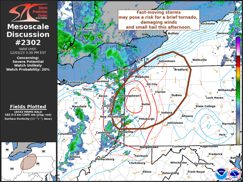
PDS Watch incoming for Central LA to MS
quote:
Mesoscale Discussion 2302
NWS Storm Prediction Center Norman OK
0134 PM CST Sat Dec 28 2024
Areas affected...portions of eastern Texas into Louisiana...western
Mississippi...and extreme southeastern Arkansas
Concerning...Severe potential...Tornado Watch likely
Valid 281934Z - 282100Z
Probability of Watch Issuance...95 percent
SUMMARY...The anticipated primary round of severe storms is expected
to take shape soon. A QLCS, likely preceded by supercells, with all
severe hazards expected. Several EF0-EF2 tornadoes are anticipated,
and a few intense (EF3+) tornadoes are likely. A particularly
dangerous situation tornado watch will be issued within the next
hour or so to address the increasing severe threat.
DISCUSSION...A QLCS is gradually organizing across eastern TX,
preceded by multiple supercells developing within confluence bands.
So far, tornadoes have been the predominant observed severe hazard,
with preliminary local storm reports suggesting that some of these
tornadoes may have been strong. Mesoanalysis trends have shown a 70
kt mid-level jet streak pivoting the trough and approaching the open
warm sector, characterized by 2000-2500 J/kg MLCAPE (given 7 C/km
mid-level lapse rates atop 70F surface dewpoints). As such, the 850
mb low-level jet has already increased to 40 kts, with regional VADs
beginning to show the first signs of low-level hodograph
enlargement.
Trends of increasing low-level shear across the warm sector should
continue into the evening hours ahead of the approaching QLCS and
supercells. Damaging tornado potential should not only persist, but
likely increase into the evening hours, both with the QLCS and
preceding supercells. The most discrete, dominant warm-sector
supercells will have the best potential to produce intense,
potentially long-lived/long-tracked tornadoes. In consideration of
the aforementioned significant tornado potential, a particularly
dangerous situation tornado watch is likely within the next hour.
This post was edited on 12/28/24 at 1:42 pm
Posted on 12/28/24 at 1:43 pm to ElOsoBlanco7
Headed toward 146 then will go into the bay south of kemah likely. Bacliff in immediate peril.
Windfield 3 miles wide per abc13
Windfield 3 miles wide per abc13
This post was edited on 12/28/24 at 1:46 pm

 Page 5 of 26

Popular
Back to top