- My Forums
- Tiger Rant
- LSU Recruiting
- SEC Rant
- Saints Talk
- Pelicans Talk
- More Sports Board
- Fantasy Sports
- Golf Board
- Soccer Board
- O-T Lounge
- Tech Board
- Home/Garden Board
- Outdoor Board
- Health/Fitness Board
- Movie/TV Board
- Book Board
- Music Board
- Political Talk
- Money Talk
- Fark Board
- Gaming Board
- Travel Board
- Food/Drink Board
- Ticket Exchange
- TD Help Board
Customize My Forums- View All Forums
- Show Left Links
- Topic Sort Options
- Trending Topics
- Recent Topics
- Active Topics
Started By
Message
re: I-10 Severe Weather threat - Monday May 13, 2024...
Posted on 5/13/24 at 6:44 pm to Impotent Waffle
Posted on 5/13/24 at 6:44 pm to Impotent Waffle
You definitely don't want to be driving in this. Any of you folks who know someone who is on the road with this headed toward them, give them a call and tell them to pulls off somewhere for a bit.
 3
3

Posted on 5/13/24 at 6:45 pm to LegendInMyMind
Man WHAT THE frick was that.. Here in Youngville that was insane!
Posted on 5/13/24 at 6:45 pm to jmcwhrter
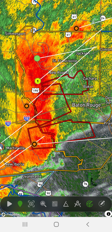
Is Baton Rouge gonna take a direct hit?

Posted on 5/13/24 at 6:45 pm to LegendInMyMind
Yup.. driving west
On I-10 from BR is not a good idea.
On I-10 from BR is not a good idea.
Posted on 5/13/24 at 6:46 pm to Govt Tide
Lafayette Kaliste Saloom/E Broussard trees down.
One in my back yard!
One in my back yard!

Posted on 5/13/24 at 6:47 pm to ItzMe1972
Has anyone verified anything is on the ground? The winds kinda of make it a dont care since they are in the triple digits.
Posted on 5/13/24 at 6:48 pm to dukke v
BULLETIN - EAS ACTIVATION REQUESTED
Tornado Warning
National Weather Service New Orleans LA
643 PM CDT Mon May 13 2024
The National Weather Service in New Orleans has issued a
* Tornado Warning for...
Central Iberville Parish in southeastern Louisiana...
* Until 715 PM CDT.
* At 642 PM CDT, severe thunderstorms capable of producing both
tornadoes and extensive straight line wind damage were located 10
miles east of Butte La Rose, or 11 miles east of Catahoula, moving
east at 55 mph.
HAZARD...Tornado.
SOURCE...Radar indicated rotation.
IMPACT...Flying debris will be dangerous to those caught without
shelter. Mobile homes will be damaged or destroyed.
Damage to roofs, windows, and vehicles will occur. Tree
damage is likely.
* These dangerous storms will be near...
Plaquemine around 655 PM CDT.
St. Gabriel around 700 PM CDT.
Posted on 5/13/24 at 6:48 pm to LegendInMyMind
Hopefully the strongest part
Will stay to the south ofI-12 corridor.
Will stay to the south ofI-12 corridor.
Posted on 5/13/24 at 6:48 pm to LegendInMyMind
The tornado warnings with this don't make a difference at the moment. The wind is as dangerous as the type of tornado this would likely put down. Treat that whole portion of the line like a tornado warning, especially if you or someone you know is driving.
Posted on 5/13/24 at 6:49 pm to LegendInMyMind
Take cover now if you’re in new roads!!!!
Posted on 5/13/24 at 6:50 pm to Walt OReilly
Be careful Baton Rouge. Bad weather just over Lafayette. 80 mph wind gusts
Posted on 5/13/24 at 6:50 pm to LegendInMyMind
Acadiana airport weather station hasn't reported kn 9 minutes, it may be down.
Posted on 5/13/24 at 6:50 pm to NorthEndZone
BULLETIN - EAS ACTIVATION REQUESTED
Severe Thunderstorm Warning
National Weather Service New Orleans LA
637 PM CDT Mon May 13 2024
The National Weather Service in New Orleans has issued a
* Severe Thunderstorm Warning for...
Western Ascension Parish in southeastern Louisiana...
Iberville Parish in southeastern Louisiana...
Northwestern Assumption Parish in southeastern Louisiana...
* Until 730 PM CDT.
* At 635 PM CDT, severe thunderstorms were located along a line
extending from near Butte La Rose to near Lake Fausse Pointe to
near New Iberia, moving east at 65 mph.
THESE ARE DESTRUCTIVE STORMS FOR BAYOU SORREL and PLAQUEMINE.
HAZARD...80 mph wind gusts and quarter size hail.
SOURCE...Radar indicated.
IMPACT...Flying debris will be dangerous to those caught without
shelter. Mobile homes will be heavily damaged. Expect
considerable damage to roofs, windows, and vehicles.
Extensive tree damage and power outages are likely.
* Locations impacted include...
Gonzales, Donaldsonville, Plaquemine, St. Gabriel, White Castle,
Prairieville, Paincourtville, Geismar, Bayou Sorrel, Carville, and
Belle Rose.
This includes Interstate 10 in Louisiana between mile markers 171 and
181.
Posted on 5/13/24 at 6:51 pm to Walt OReilly
I do not want to be on the BTR Mississippi River Bridge atm 
Posted on 5/13/24 at 6:52 pm to 50_Tiger
Most surprising is that WAFB is continuing with regular news and commercials and WBRZ is all weather. Usually the opposite.
Posted on 5/13/24 at 6:53 pm to LegendInMyMind
Tornado sirens going off in St Gabriel. Can hear them from Uclub

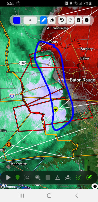
Posted on 5/13/24 at 6:55 pm to LegendInMyMind
shite, I'm right up this mess in a few minutes.

Posted on 5/13/24 at 6:55 pm to tigercraig
We need to activate the bubble. Usually this stuff splits BR.
Barksdale has there weather bubble perfected
Barksdale has there weather bubble perfected
Posted on 5/13/24 at 6:57 pm to tigercraig
These aren't the type of tornadoes you track. Any of these rotations can put down a tornado at any point and be gone by the time the next radar scan comes in.

 Page 9 of 26

Popular
Back to top