- My Forums
- Tiger Rant
- LSU Recruiting
- SEC Rant
- Saints Talk
- Pelicans Talk
- More Sports Board
- Fantasy Sports
- Golf Board
- Soccer Board
- O-T Lounge
- Tech Board
- Home/Garden Board
- Outdoor Board
- Health/Fitness Board
- Movie/TV Board
- Book Board
- Music Board
- Political Talk
- Money Talk
- Fark Board
- Gaming Board
- Travel Board
- Food/Drink Board
- Ticket Exchange
- TD Help Board
Customize My Forums- View All Forums
- Show Left Links
- Topic Sort Options
- Trending Topics
- Recent Topics
- Active Topics
Started By
Message
re: 5/6 Oklahoma/Kansas severe weather - High Risk- PDS Tor Watch
Posted on 5/6/24 at 10:35 pm to LegendInMyMind
Posted on 5/6/24 at 10:35 pm to LegendInMyMind
They don’t pull the trigger easily on tornado warnings at NWS Norman/OKC. I would have slapped a radar indicates warning on the cell near Meridian just in case, but the velocity is still very broad.
 0
0


Posted on 5/6/24 at 10:36 pm to AllDayEveryDay
quote:
If you don't have a shelter, wtf do you even do in that situation?
Try to get to a sturdy structure if at all possible, putting as many walls as you can between you and the outside.
Posted on 5/6/24 at 10:36 pm to OU Guy
Storms coming from SW of OKC


Posted on 5/6/24 at 10:37 pm to Pedro
quote:thinking more on it I think one of the places they went to they literally had a person assigned to each siren that had to go out and turn a key to turn it on. I may be misremembering but that’s sticking out in my mind for some reason.
seem to remember hearing a news story a couple years ago about towns here in Kansas having outdated tornado warning systems. Would imagine a place like barnsdale could have the same issue.
Posted on 5/6/24 at 10:42 pm to Pedro
Posted on 5/6/24 at 10:46 pm to Roll Tide Ravens
Damn that’s bad. Seems consistent with ef3ish in that photo. Guess it depends on if that house in the background is off of its foundation and how well built it was.
Posted on 5/6/24 at 10:46 pm to Pedro
quote:
thinking more on it I think one of the places they went to they literally had a person assigned to each siren that had to go out and turn a key to turn it on. I may be misremembering but that’s sticking out in my mind for some reason
Had a setup like that at a small town here in MO, tornado went between them and the siren
Posted on 5/6/24 at 10:49 pm to SidewalkTiger
Yea that doesn’t surprise me. Seems something like that would be a better use of federal dollars to make sure these small broke towns can fix instead of shipping off billions to other countries…
But I digress…
But I digress…
Posted on 5/6/24 at 10:49 pm to SidewalkTiger
Posted on 5/6/24 at 10:51 pm to BigBro
quote:
in the Reed Timmer chat, there are some saying 250 mph reported at airport near Bartlesville.. that’s a strong F4 if it’s verified.. stay safe out there
I doubt this very seriously. In fact, I'm just gonna outright call bullshite. The tornadic part of the storm missed the airport, and the publicly accessible weather station at the airport recorded a 45mph max gust, and it is still reporting as of 10:40pm.
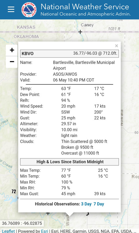
The other station near Bartlesville would have been closer to the tornado, and it recorded a max gust of 53mph and is still reporting as of 10:45pm.
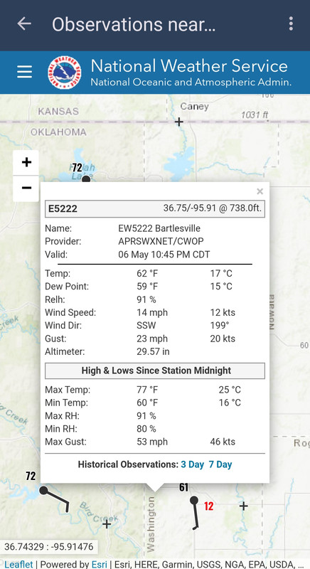
This post was edited on 5/6/24 at 10:55 pm
Posted on 5/6/24 at 10:52 pm to OU Guy
quote:
We’re really hoping this doesn’t produce a tornado in the metro.
Sometimes I wonder if there is any actual truth behind this from the click-baity Twitter folks.
Posted on 5/6/24 at 10:52 pm to LegendInMyMind
People in these storm chaser, Ryan Hall, etc chats say some really dumb stuff
Posted on 5/6/24 at 10:54 pm to LegendInMyMind
That’s what I was thinking for Hurricane Laura the LCH radar got knocked off after 130 mph and I think and their setup could take more of an impact than Bartlesville could
Posted on 5/6/24 at 10:56 pm to slackster
This cell headed to OKC is taking on a really weird satellite shape. Almost like a reverse hook echo. 
Posted on 5/6/24 at 10:57 pm to SWLA92
quote:
That’s what I was thinking for Hurricane Laura the LCH radar got knocked off after 130 mph and I think and their setup could take more of an impact than Bartlesville could
You'd be surprised at the differences in weather station quality and installation. Japan does it better than anyone, and they get some huge wind recordings.
Our weather station network runs the spectrum from pretty dang good to absolute shite. I don't think we have one anywhere within the NOAA network that would survive long enough to record 200+.
ETA: There are some mesonet sites out there that could maybe do it, but most aren't publicly accessible.
This post was edited on 5/6/24 at 10:58 pm
Posted on 5/6/24 at 11:01 pm to slackster
Yea that’s odd. It’s happened before but it was on a cell moving from southeast to northwest in Nebraska.
Posted on 5/6/24 at 11:01 pm to LegendInMyMind
Tornado warning for that storm within the line north of OKC now.
Posted on 5/6/24 at 11:01 pm to Pedro
quote:
I seem to remember hearing a news story a couple years ago about towns here in Kansas having outdated tornado warning systems. Would imagine a place like barnsdale could have the same issue.
Topeka had the opposite problem last week. They sounded the sirens and then due to something in the software they couldn't turn them off when everything had passed by.
Posted on 5/6/24 at 11:02 pm to SWLA92
New tornado warning northeast of OKC.


 Page 25 of 30

Popular
Back to top